By Walter Elliott
ESSEX – The ‘Local Talk” area, while dodging one of five tornadoes during July 29’s thunderstorms, found themselves up to waist-deep in the afternoon and evening run-off in some areas.
The National Weather Service said that a tornado packing 65 mph winds had touched down on the West Orange side of the Montclair Country Club at 5:53 p.m. that Thursday. It would be among five tornadoes recorded statewide that night.
The up-to-50-foot-wide twister then went due north into Verona before breaking up at the Verona Park bike path at 5:57 p.m. – three minutes and .35 mile later.
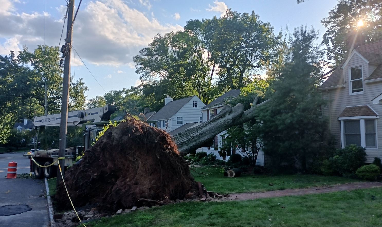
Verona first responders counted three felled trees and 10 to 20 major tree limbs falling onto its lawns and streets. One tree fell on a Sylvan Road home, causing roof damage. A second tree that was uprooted by a street, caused borough officials to call Public Service Electric & Gas over to check for any gas main leaks.
The NWS placed the West Orange-Verona tornado at zero on the Enhanced Fuijita wind scale. It would have rated an EF-1 score had its winds had blown to at least 77 mph.
This and four other tornadoes were parts of two thunderstorm bands that raked through New Jersey 2-9 p.m. Heavy thundershowers doused a “Local Talk” delivery crew while they were going through Newark’s Forest Hill and Lower Broadway sections 2-3 p.m.
“Local Talk” was also among riders whose weather emergency alarms went off on their cell phones while on a northbound New Jersey Transit No. 13 bus at 5:50 p.m.
The NWS had issued a Tornado-Severe Thunderstorm Warning for the Caldwells, Upper Montclair, Glen Ridge and Bloomfield’s Brookdale section through 6 p.m. Although the storm cell was heading east towards Nutley, Belleville and North Newark, the service called for listeners to take shelter.
“Flying debris will be dangerous to those caught without shelter,” said the warning. “Mobile homes will be damaged or destroyed. Damage to roofs, windows and vehicles will occur. Tree damage is likely.”
A 6:30 NWS emergency alert called for listeners/readers to “take shelter now in a basement or an interior room on the lowest floor of a sturdy building. If you’re outdoors, in a mobile home or in a vehicle, move to the closest substantial shelter. Check media.”
Although the tornado alerts were focused on the northern third of Essex County, the alerts were issued throughout all 22 county towns.
One Maplewood resident who got the 5:50 p.m. alert “went downstairs anyway” and “called Maplewood police and they knew nothing about it. “The Maplewoodian stayed down until 6:30 p.m. but TV weather was saying it was south of here.”
Media weathercasters may have been referring to the four other EF-1 and -2 tornadoes in Hunterdon, Burlington and – twice – in Ocean counties. Up to 35 homes were damaged by twisters that packed up to 120 mph wind.
The NWS Mount Holly office ranked July 29 as the second greatest number of tornado outbreaks in a day – tied with March 10, 1964.
There had been a record nine in a 24-hour period Nov. 16, 1989. That outbreak, including one striking North Caldwell, left two people dead among seven counties.
The NWS had meanwhile issued flash flood warnings “for low-lying areas” into 7:35 p.m. and, even after the storm fronts have passed, kept the flash flood warning up until 8:45 p.m.
That warning was merited because of where and how fast the rain fell.
NWS’s rainfall recordings ranged from 2.32 inches in Essex Fells and 1.48 in Caldwell to .6 in Maplewood and .57 at Newark Liberty International Airport.
Portions of the Second and Third rivers overflowed their banks in Montclair, Bloomfield and Nutley. Flooded areas included Nutley’s Booth Park, Montclair’s Rand Park by North Fullerton Avenue and Bloomfield’s Watsessing Park. (Watsessing – where Toney’s and Wigwam brooks converge with the Second River – once held a man-made lake in the Victorian Era.)
The floodwater’s current was greater than carrying away soccer balls and tree branches. Nutley’s Kingsland Park pedestrian bridge had been stripped of its deck and railing.
Flooding also concentrated under NJTransit’s Montclair-Boonton Line railroad bridges in Montclair. One car, with water up to its wheel wells, remained stalled under the Watchung Plaza trestle.
Flooding on Route 3 at Nutley-Clifton’s Bloomfield Avenue left several cars stranded on the state highway in both directions. It and the resulting detours affected NJTransit’s 13 and 190-series buses.
The bad weather prompted the Belleville Recreation Department to reschedule its Jersey Sounds Summer Concert at Belleville High School to Sept. 2. It had also forced the Newark Department of Public Safety to reschedule its 10 a.m.-6 p.m. “Fun in the Sun” day at Mercer and Broome streets to Aug. 5.
Newark’s PSD, at 2:30 p.m., had posted a list of 37 streets and intersections for people to avoid for citywide flooding except for the North Ward.